Strategy: The Gulf of Argentario and the Bay of Talamone
For those who are planning to sail in Talamone for the next Junior or Senior Worlds By Alessandro Testa Talamone is a small village located in the northern part of Costa d’Argento (Silver Coast) of Italy, at the northern end of the big Gulf of Argentario. The Gulf is enclosed by the Argentario promontory to the south and by the mountains of Uccellina to the north, where the Maremma Park is located. The gulf is about 6 miles long and about 2 miles wide. All around, a few miles away, many of the islands of the Tuscan Archipelago: Giannutri, Isola del Giglio, the Formiche di Grosseto, Pianosa, Elba Island. The Mediterranean climate, low rainfall, the high sun exposure (the highest in Italy), the mountains and characteristics of the surrounding area make the Costa d’Argento and in particular the Bay of Talamone one of the most beautiful and interesting race areas in Italy. ...
For those who are planning to sail in Talamone for the next Junior or Senior Worlds
By Alessandro Testa
Talamone is a small village located in the northern part of Costa d’Argento (Silver Coast) of Italy, at the northern end of the big Gulf of Argentario. The Gulf is enclosed by the Argentario promontory to the south and by the mountains of Uccellina to the north, where the Maremma Park is located. The gulf is about 6 miles long and about 2 miles wide. All around, a few miles away, many of the islands of the Tuscan Archipelago: Giannutri, Isola del Giglio, the Formiche di Grosseto, Pianosa, Elba Island.
The Mediterranean climate, low rainfall, the high sun exposure (the highest in Italy), the mountains and characteristics of the surrounding area make the Costa d’Argento and in particular the Bay of Talamone one of the most beautiful and interesting race areas in Italy.
…
The wind patterns are beneficially affected both by the movement of air due to the passage of fronts along the Tyrrhenian Sea and by the vigorous and prolonged thermal breezes that occur from late April to late October. In particular the Bay of Talamone, for its particular conformation, makes the wind blow 5-8 knots higher than in other areas of the Gulf of Argentario and for more hours during the day. For this reason and for the presence of a large area of shallow water in the inner part of the bay, Talamone, besides being a great training area for sailing, has become one of the most renowned national spots for kitesurfing and windsurfing.
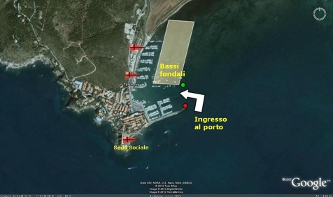
The Port of Talamone is located west of the Bay of Talamone and is protected by the mountains of Uccelina and the promontory where the old village is situated, from winds from the second, third and fourth quadrants (East-North). Winds from the first quadrant, due to the limited fetch and the area of shallow water that extends to the east, do not represent a threat to the natural shelter offered by the Port of Talamone.
To help you understand the conditions of the race area—the wind, the sea and currents of the Gulf of Argentario and the Bay of Talamone—we try to describe, with the help of the image below, the coast around Talamone.
To the north of Talamone, parallel to the coastline, the mountains of Ucellina stretch up to 400 meters high. On the slopes of these mountains, a great plain extends to the north, around the city of Grosseto, intensively cultivated arable land, which continues with the valley of Collecchio up almost to the Bay of Talamone.
To the east, except for the low hill of Talamonaccio, another wide cultivated plain, called San Donato, extends to the sea with a thick pinewood.
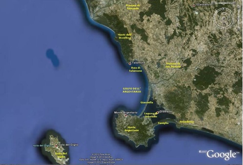 To the east-southeast there are the hills on the border with the territory of Capalbio ending with the promontory of the ancient Etruscan town of Ansedonia.
To the southeast, between these hills and the promontory of Monte Argentario, up to 600 meters high, there is an area with a low coast where the old Spanish town of Orbetello is located, built in the middle of a large lagoon separated from the sea by a tombolo (a thin strip of land) of Feniglia (a nature reserve) to the south and by tombolo della Giannella to the north.
To the south the wide and high promontory of Monte Argentario defends the Gulf of Argentario from strong winds from the south and southwest and heavy seas.
To the southwest, divided by a few miles from the Promontory of Argentario, there is the Island of Giglio that protects still further the Gulf of Argentario.
To the west and northwest the Gulf of Argentario is open to the sea, without protection, with only the distant but efficient shield of Corsica and of the Island of Elba.
In essence, the hills of Uccellina accelerate and funnel the powerful summer thermal breeze from northwest, triggered by a significant heating on the surrounding plains. Monte Argentario and Giglio Island protect the bay from storms coming from the south and southwest. When the south wind blows, more often in the cold months than in warm, the wind passes through the lagoon of Orbetello, while the waves from the Tyrrenian Sea are blocked by the tombolo della Feniglia.
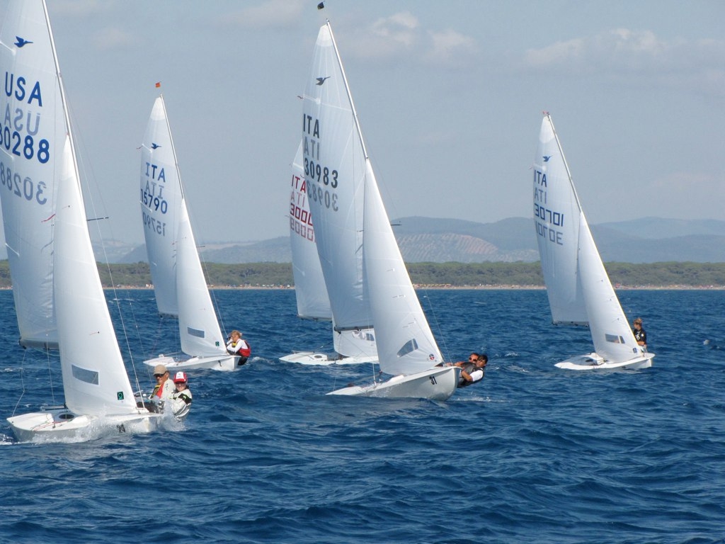
The Bay of Talamone is where the race course for the dinghies is normally positioned.
During the cold months (8°C-16°C during the day) the prevailing winds come from the northeast (from light breeze to 30 knots and over), from the southeast (10-20 knots), from the southwest and west with sea breeze and good weather (4-10 knots) or gradient wind (25-40 knots). The breezes (northeast and southwest to west) are generated, for intensity and stability, by the gradients that occur during the cold months on land and sea.
During the warm months (18°C-30°C), from late April to October, the prevailing winds are from the southwest and west (4-15 knots), from the southeast (6-20 knots) and the northwest (5-25 knots). In particular, the latter wind produces in the second part of the day a beautiful and powerful wave that allows exciting upwind legs and full plane reaches.
Currents other than those of seasonal circulation Tyrrhenian (a few cm per second) are scarce and rare. They do happen after to the passage of storms, due the flow into the sea of rain from the Ombrone rivers in the north and Albegna in the southeast.
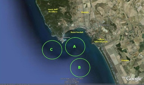 Depending on wind conditions and sea states, the race committee may decide to place the race course in three different areas:
Area A – closest to the innermost part of the Bay and the Port of Talamone is characterized by great pressure, gusty conditions, huge shifts due to the proximity of the coast. It is the most spectacular race area.
Area B – further south than area A and farthest from the coast, it is different from area A because it has more steady wind for direction and intensity, less wind speed and more homogeneous wind across the race course, and no influence of the coast. The racing area is used when you want to sail on a neutral field without a favored side of the course.
Area C – northwest from areas A and B, it is characterized by lighter wind, instability and variability due to its proximity to the steep mountains of Uccellina, more chop, and different areas of pressure. Area C is used when area A is too windy, or if the race committee wants to relocate the race course after one or more races that have had a very favored side.
Leave a reply
Your email address will not be published. Your comment will be revised by the site if needed.

0 comments